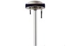
ProMark 500
Multi-constellation GNSS receiver
The ProMark 500 rover and rover/base system offer GPS+GLONASS field-proven technologies for surveying and geodesy. This is a powerful RTK survey solution delivering precise GNSS positioning in a smart, rugged, cable-free and flexible design.
Advanced BLADE Technology
Embedded BLADE Technology introduces a unique patented way to use multiple GNSS constellations for high-accuracy positioning.
· Short time-to-fix, and long-range RTK positioning
· Patented multi-constellation signal processing
· Use of SBAS and GLONASS ranging signals to strengthen the GPS solution
· Extended solution reliability in urban canyon and under tree canopy
The mix of exceptional RTK performance and compact design makes the ProMark 500 an extremely powerful and appealing RTK solution for demanding professional land surveyors.
All-in-one Flexibility
ProMark 500 includes extended wireless network communications modules, for maximum mobility and flexibility in the field.
· UHF and GSM/GPRS/EDGE built-incommunication modules
· Multiple operating modes and configurations
· Extended support of protocols and data formats
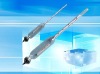
· Choice of state-of-the-art field terminals
Feature-rich Surveying Solution
ProMark 500 offer includes field and office software as well as field terminal choice to ensure you get a robust, ready-to-use, cable free RTK rover solution.
· FAST Surveyfield software simplifies data collection and real-time operation.
· GNSS Solutionsoffice software provides powerful support to a wide range of applications.
· Real Time Data Server Software (RTDS) is a software offering land surveying companies the possibility of using GNSS equipment to build their own Direct IP RTK corrections server.
Product specifications
- Constellation :GPS, GLONASS, SBAS
- Frequency :L1, L2
- Channels :75
- Update Rate :0.05 sec
- Data format :RTCM 3.1, ATOM, CMR (+), NMEA
- Raw data output :Yes
- Real-time Accuracy - RTK mode (HRMS) :1 cm
- Real-time Accuracy - DGPS mode (HRMS) :< 30 cm
- Real-time Accuracy - SBAS mode (HRMS) :< 50 cm
- Post-Processed Accuracy (HRMS) :0.3 cm + 0.5 ppm
- Time to first fix :2 sec
- Initialization range :Up to 40 km
- Communications :UHF, GSM/GPRS, BT
- Unit size (mm / inches) :228x188x84mm / 9x7.4x3.3in
- Weight :1.4 kg / 3.1 lb
- Display :OLED
- Memory :128 MB + USB
- Temp Min (°C) :-30°C / -22°F
- Temp Max (°C) :55°C / 131°F
- Waterproof :Yes
- Shock & vibration :ETS300 019 & EN60945
- Power (type - lifetime) :4600 mAh Li-Ion / > 7 hrs
- Antenna Type :Internal
- Firmware options :Yes
- Software options :Yes