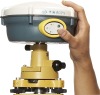
1. Built-in transmit-receive UHF, exchangeable Base and Rover.
2. The radio power is adjustable to be 0.1w, 1w, 2w.
3. 1+X multi-module communication units.
4. PCC Radio module (optional) compatible with Trimble/Leica RTK.
5. Double battery capacity as 4400mAh, 12 hours for RTK operating.
6. The highest performance in waterproof, dustproof and anti-drop.
7. Trimble BD970 mother board, multi-satellite, multi-system kernel.
8. Supper long distance external radio(optional).
9. With the intelligentialized self-diagnosis function
10. Config Multi-function RTK controller iHand1 series. Voice navigation of RTK handheld software.
The combination of the top GNSS industry’s technologies, V30 gives you completely innovative user experiene.
Application:
Construction Lay Out
Abundant point and line lay out function, assistant by graph operation instruction, save your expenditure in practical construction.
Electricity and Transportation
Friendly function on power line route direction survey, distance survey and angle calculation; comprehensive survey functionality on road survey, center line, offset survey, profile and cross-section survey.
CORS Application
Seamlessly compatible with CORS system, only one RTK rover can receive CORS difference signal and carry out data collection, construction lay out work.
CORS Station Establishment
HD-CORS apply profound experience and mutual technology, stable on operation, long distance on data transmission, is your first choice for city continuous reference stations system.
Control Survey
Only one investment you can get list of function, v30 dual frequency static survey accuracy can satisfy any requirements, config with mutual professional data solution software. You can easily accomplish various high precision control survey work.
Data conllection
Cotroller operation software designed for GIS application, convenient coding function, meets all your requirements in field data collection work.