HD8200X Integrated Intelligent Static GPS
HD8200X integrated intelligence static GPS is the new generation of Hi-Target static GPS surveying system basing on ten years static technology accumulation and up to thousands of customers
application experience. HD8200X is featured with outstanding appearance, exquisite innovation technology, and powerful
function.
Entirely Integrated Design
Integrated design with all key components built-in, highly sealed, waterproof, dustproof, quakeproof.
Mainframe chip adopts ARM7 structure of 32 processors.
Intelligent Vocal Technology
Vocal intelligent technology initially adopted in surveying field, vocally indicate operation and status, realizing man-machine dialogue.
Mass Memory Technology
64M memory, U disc memory technology, directly tows and downloads data.
The Project Document Management
System adopts project data document management pattem, greatly lengthen Flash service life via writing balance
technology.
Concise Operation
Concise operation system, essential parameters such as satellite number, sampling interval and mask angle can be set
in the panel directly.
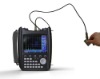
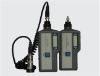
Wireless controller
Control the start and end of the static file directly on panel without turning the mainframe off.
1296 static files at the most can be collected in one day.
Attached with a control to implement starting/ending static file, naming file, refreshing and viewing the list and viewing
satellites status.
System Parameter
| Specification | Parameter | Physical Parameter |
| Horizontal: ±(5mm+1ppm) | Mainboard: Parallel 12 Channels + L1 C/A | Mainframe:600g |
| Vertical: ±(10mm+1ppm) | Epoch Interval:1S-60S Adjustable | Dimension:19cm×10cm |
| Working Distance≤ 50km | Satellite Mask Angle: 0°- 60°Adjustable | Working Environment:-40°C~70°C |
| Accessory | Main Power Loss:1.36W | Storage Environment:-50°C~80°C Waterproof,Dustproof |
| Software:HD-2003 Data Processing | Data Communications:USB/RS-232 | Power System |
| Function:Baseline Processing, Network Adjustment, Height Fitting, Report | Data Storage | Battery:Double Lithium Batteries |
| Compatibility:Baseline Combined Solution, Combined Surveying and Calculation with Different Brand Instrument | Memory:64M | Voltage:7.2V |
| Memory Media:Flash EPROM | Working Time:16Hours |
| Power Failure Protection:10Years | Charging Time: <4 Hours |
Accessories
HD8200X Integrated Main Body
>> Highly Integrated Design with all Key Components Built-in, PVC Crust, Fall-proof from 2 Meters High
>> Professional Waterproof Design, Floatable
Professional Lithium Power System
>> Built-in Double Lithium Batteries, Uninterrupted Charging, Large Capacity Supporting 16 Hours Working
HighSpeedUSBCommunicationPort
>> 64M Large Capacity Flash Memory, 160 Hours Data Collection Continuously
>> USBCommunicationPort, U Disc Static File Data Download
Intelligent Verbal Indication
>> Verbal Intelligent Technology, Verbal Indicate Operation and Status, Guide to Know the Working Status Clearly
GPS Post Processing Software
>> Professional Post-Processing Software, Use Friendly to Have Man-Machine Conversation, Detailed Report Output
>> Post Difference Data Solution Function
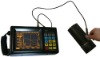
Remote Controller Terminal
>> Bluetooth, touch screen, convenient for view info, enter info&down loading data, especially suitable for post-difference working.
Application
Widely Utilizes to Construction Application Scope in Control Survey, Project Survey, Area Survey, GIS Data
Acquisition and Distortion Survey. Post Difference Function is Especially Appropriate Long-Distance Range GIS Data Acquisition Work Pattern.