Product Features:
Our radar is designed to solve problems in the field of geology exploration.
Business Terms:
Minimum Order Quantity: 1 Set/Sets
Supply Ability: 100 Set/Sets per Year
Payment Terms: L/C,T/T
Contact Supplier
Our radar is designed to solve problems in the field of geology exploration.
Minimum Order Quantity: 1 Set/Sets
Supply Ability: 100 Set/Sets per Year
Payment Terms: L/C,T/T
Contact Supplier
Our radar is designed to solve problems in the field of geology exploration:
1. Determination of the boundaries and structure of rock layers at depths up to 300m;
2. Mapping the position of individual objects (ore bodies etc.). Development of active radar subsurface sounding systems designed to solve problems of engineering geology, especially for explorations at depths of several hundred meters to several kilometers.
Advantages
1. The significant reduction of work (more than 10 times) thanks to high speed research (measuring an area of 500x500 meters can be executed in one day);
2. High Resolution Power (depth – approximately 10m in the horizontal plane - approximately 20 cm- 30cm due to the change of aperture synthesis antenna in measuring and memorizing the amplitude-phase structure of the signal at discrete points on a relatively large area;
3. A dramatic reduction in the number of drilling that would usually be necessary (approximately ten times).
Areas Of Use
1. Diagnosis of the soil beneath the surface of cities, industrial centers and buildings (evaluation of moisture soil layers, the detection of pipeline leaks). Estimate the degree of hydration, the presence of soil and tunnel decompression;
2. Diagnosis of the subsurface structure and assessment of soil landslides. Mapping zones of subsurface distribution of liquid petroleum products as a result of leakage from storage sites in industrial areas;
3. Assessment and monitoring of subsurface soil structure (including the mapping of groundwater levels at depths up to 300 m);
4. Identification and mapping of subsurface petroleum accumulations zones at depths up to 300 m;
5. Detection of voids, and less dense substance soil decompaction as a result of geological changes or anthropogenic influences;
7. Determining the status of foundations and building structures of existing facilities;
8. Detection and identification of mines, explosive charges, shells and other ammunition, including plastic-coated;
9. Mapping of underground communication facilities (cables, pipelines, tunnels);
12. Mapping of subsurface zones in archaeological excavations.

Model No.: KP-90n
Features: KP-90N digital map planimter,
1.good operation
2.accuracy:<=2%
3.convenience to take along

Model No.: KP-90n
Features: KP-90N digital planimter,
1.good operation
2.accuracy:<=2%
3.convenience to take along
Model No.: KP-90n
Features: KP-90N digital map planimter,
1.good operation
2.accuracy:<=2%
3.convenience to take along
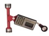
Model No.: KP-92n
Features: KP-92N map planimeter
Measurement by 6 dlglt pulse count
Maximum cumulative measurement value of 10m2
Hold memory function

Model No.: KP-92n
Features: KP-92N map planimeter
Measurement by 6 dlglt pulse count
Maximum cumulative measurement value of 10m2
Hold memory function

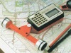
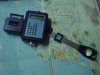
Model No.: kp-21c
Features: map planimeter KP-21C
1.length and coordinates data simultaneously
2.Quality assurance
3.Best price
Model No.: kp-21c
Features: map planimeter KP-21C
1.length and coordinates data simultaneously
2.Quality assurance
3.Best price

Model No.: kp-21c
Features: map planimeter KP-21C
1.length and coordinates data simultaneously
2.Quality assurance
3.Best price

Model No.: kp-21c
Features: map planimeter KP-21C
1.length and coordinates data simultaneously
2.Quality assurance
3.Best price

Model No.: kp-21c
Features: map planimeter KP-21C
1.length and coordinates data simultaneously
2.Quality assurance
3.Best price

Model No.: kp-21c
Features: map planimeter KP-21C
1.length and coordinates data simultaneously
2.Quality assurance
3.Best price

Model No.: kp-21c
Features: map planimeter KP-21C
1.length and coordinates data simultaneously
2.Quality assurance
3.Best price