Product Features:
Scanning ground penetrating geo - radar, adapted for engineering, geology, hydrogeology
Business Terms:
Minimum Order Quantity: 1 Set/Sets
Supply Ability: 100 Set/Sets per Year
Payment Terms: L/C,T/T
Contact Supplier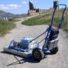
Scanning ground penetrating geo - radar, adapted for engineering, geology, hydrogeology
Minimum Order Quantity: 1 Set/Sets
Supply Ability: 100 Set/Sets per Year
Payment Terms: L/C,T/T
Contact Supplier
This device is designed specifically to address the problems of engineering geology, hydrogeology and ecology. The main advantage is the ability to scan information on the physical properties of the environment and individual sub-surface discontinuities. This feature is implemented through the use of a phase structure of signals reflected on subsurface heterogeneities to receive images of objects, using holographic processing
Advantages
Relatively slow change of the carrier frequency of the probing signal makes it possible to evaluate the electrical characteristics of the environment directly in the radar data.
Our technology has no known analogues. Advantages over conventional methods and geo-research and hydrogeology (drilling) are:
- Efficiency of work performance (speed of execution of works several times faster);
- Significant reduction in the cost of works by reducing drilling (number of wells required is reduced by several times);
High-resolution in all three dimensions (depth and horizontal plane);
Weakening of interfering signals arising from the effects of reflections from various objects on the ground (communication engineering structures, buildings, electrical wires, etc.).
Areas Of Use
1. Diagnosis of the soil beneath the surface of cities, industrial centers and buildings (evaluation of moisture soil layers, the detection of pipeline leaks). Estimate the degree of hydration, the presence of soil and tunnel decompression;
2. Diagnosis of the subsurface structure and assessment of soil landslides. Mapping zones of subsurface distribution of liquid petroleum products as a result of leakage from storage sites in industrial areas;
3. Assessment and monitoring of subsurface soil structure (including the mapping of groundwater levels at depths up to 25m);
4. Identification and mapping of subsurface petroleum accumulations zones at depths up to 20m as a result of leaks from their places of storage and transportation, and other environmental accidents;
5. Detection of voids, and less dense substance soil decompaction as a result of geological changes or anthropogenic influences;
7. Determining the status of foundations and building structures of existing facilities;
8. Detection and identification of mines, explosive charges, shells and other ammunition, including plastic-coated to a depth of 30 meters;
9. Mapping of underground communication facilities (cables, pipelines, tunnels);
12. Mapping of subsurface zones in archaeological excavations.

Model No.:
Features: With magnetic,super useful
we have own factory,the price
is reasonable.
the reference for you
more popular
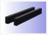
Model No.:
Features: Generally supply by pair
The special size as your requirement
With magnetic,super useful
Competitive price
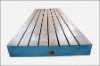
Model No.: CH1008
Features: Fot inspecting the straightness
and flatness
High precision and quality
Fast delivery and best service
Against rust
Model No.: CH1008
Features: Fot inspecting the straightness
and flatness.
High precision and quality
Jinan black granite
Thanks for your enquiry!
Model No.: CHGS-002
Features: Welcome your inquiry for special specifications
Not afraid of acid
High quality and more popular
We are good supplier
Model No.:
Features: We can make it base on customer requirement
Accuracy of measurement
competitive price and excellent service
High quality

Model No.:
Features: We can make it base on customer requirement
Accuracy of measurement
competitive price and excellent service
High quality

Model No.:
Features: We can make it base on customer requirement
Accuracy of measurement
competitive price and excellent service
High quality
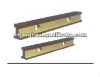
Model No.:
Features: Fot inspecting the straightness
and flatness.
High precision and quality
Jinan black granite

Model No.:
Features: Fot inspecting the straightness
and flatness.
High precision and quality
Competitive price
We have own factory

Model No.:
Features: Fot inspecting the straightness
and flatness.
High precision and quality
Jinan black granite

Model No.:
Features: Cast Iron V Block B Type
Best price and high-volume
High quality and useful
We are the best supplier